The Jurassic Coast Path map shows the full route of the South West Coast Path between Exmouth in East Devon and Studland Bay in Dorset. The route follows the coastline closely, linking coastal towns, key landmarks and natural sections of the shoreline. It provides an overview of the full walking route and how it is divided into stages.
The complete route is approximately 105 miles (169 km), with a total ascent and descent of around 13,200 ft (4023 m). While the path broadly follows the coastline, it includes frequent climbs, descents and occasional inland diversions due to cliffs and erosion.
Full Route Map
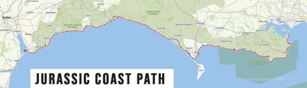
The map shows the overall layout of the route from west to east. It highlights the main access points, including Exmouth, Sidmouth, Lyme Regis, Weymouth and Swanage, as well as key landmarks along the coastline.
Route Layout
Devon Section
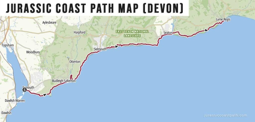
Distance: 30 miles / 48.2 km
The western section runs along the East Devon coastline from Exmouth to Lyme Regis. This part of the route includes steady cliff-top walking, with regular elevation changes and exposed sections. The path passes through Budleigh Salterton, Sidmouth, Beer and Seaton before crossing into Dorset.
Dorset Section
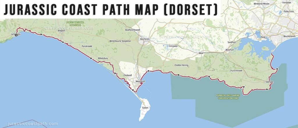
Distance: 75 miles / 120.7 km
The Dorset section continues from Lyme Regis to Studland and includes some of the most recognisable landscapes along the Jurassic Coast. The route passes through Charmouth, West Bay and Weymouth before entering the Isle of Purbeck, with sections around Lulworth Cove, Kimmeridge and Swanage.
Using the Map
A Jurassic Coast Path map helps with understanding distances, elevation and route layout. It allows walkers to identify suitable stage lengths, access points and nearby towns for accommodation and transport.
The map also highlights sections where the path diverts inland. These diversions are a normal feature of the route and are typically signposted on the ground.
Route Sections and Stages
The Jurassic Coast Path is typically divided into stages based on coastal towns and natural breaks in the landscape. These stages form the basis for planning both individual walks and longer multi-day routes.
The example below follows a structured 13-day itinerary using the full set of route stages. Distances reflect the standard breakdown of the route from Exmouth to Studland.
Example Walking Itinerary (13-days)
Exmouth to Budleigh Salterton – 5.7 miles / 9.2 km
Budleigh Salterton to Sidmouth – 7 miles / 11.3 km
Sidmouth to Beer – 8.9 miles / 14.3 km
Beer to Lyme Regis – 9.1 miles / 14.6 km
Lyme Regis to Seatown – 8.1 miles / 13 km
Seatown to Abbotsbury – 12.1 miles / 19.5 km
Abbotsbury to Weymouth – 10.8 miles / 17.4 km
Weymouth to Osmington Mills – 8.1 miles / 13 km
Osmington Mills to Lulworth Cove – 6.4 miles / 10.3 km
Lulworth Cove to Kimmeridge – 6.9 miles / 11.1 km
Kimmeridge to Worth Matravers – 7.3 miles / 11.7 km
Worth Matravers to Swanage – 6.3 miles / 10.1 km
Swanage to Studland – 7.5 miles / 12.1 km
How This Itinerary Works
This itinerary follows the full route using a consistent stage-by-stage structure. It provides a practical framework for completing the walk over multiple days, with most stages falling within a moderate daily distance range.
Some stages are shorter and can be combined, while others are longer and more physically demanding. Walkers can adjust the number of days depending on pace, accommodation availability and preferred walking distances.
For detailed information on terrain, walking times and route conditions for each stage, see the Route Stages & Distances page.