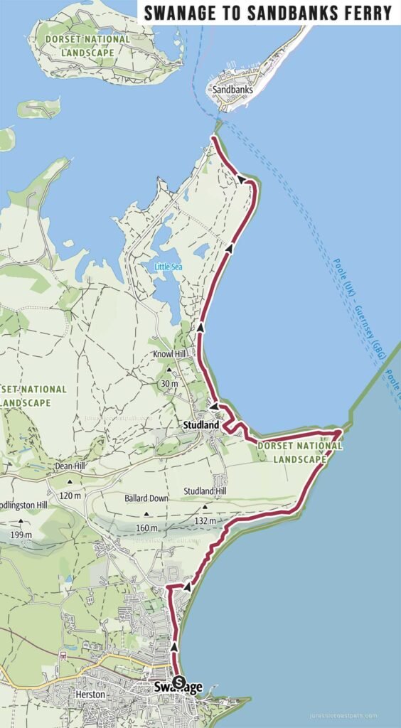
Stage Overview
- Distance: 7.5 miles / 12.1 km
- Time: 3h 15m
- Ascent: 140 m
- Difficulty: Moderate
- Terrain: Cliff paths, grassy coastal tracks, sandy sections near Studland
- Navigation: Easy (well signposted)
- Start: Swanage
- Finish: Studland (South Haven Point / Sandbanks Ferry)
- Highlights: Ballard Down, Old Harry Rocks, Studland Bay
Route Summary
This final stage leaves Swanage and climbs gradually onto Ballard Down, following a clear coastal path along the ridge. The route provides continuous views along the coastline before reaching Old Harry Rocks, one of the most distinctive landmarks on the Jurassic Coast. From here, the path descends towards Studland, transitioning from cliff-top walking to more open and sandy terrain. The stage finishes at South Haven Point, where the chain ferry connects to Sandbanks.
Elevation & Difficulty
With approximately 140 metres of ascent, this is a relatively easy stage in terms of elevation. The main climb onto Ballard Down is steady rather than steep, followed by mostly gentle terrain. The distance and path conditions allow for a comfortable walking pace, making this a suitable final stage.
Highlights Along the Route
- Swanage Seafront – Starting point with beach and town facilities.
- Ballard Down – Elevated ridge offering panoramic coastal views.
- Old Harry Rocks – Chalk stacks marking the eastern end of the Jurassic Coast.
- Studland Bay – Wide sandy beaches and open landscape.
- South Haven Point – Final point of the route with ferry access to Sandbanks.
Practical Information
- Parking (Swanage): Multiple car parks in the town and near the seafront.
- Parking (Studland): Car parks available near the beach and ferry area.
- Public Transport: Bus services connect Swanage and Studland; the Sandbanks ferry provides onward access to Poole.
- Toilets: Available in Swanage and at Studland.
- Food & Drink: Extensive options in Swanage; cafés and facilities available at Studland.
- Water: Limited refill points along the route — carry sufficient water.
Navigation Notes
The route is clearly signposted as part of the South West Coast Path. Navigation is straightforward, with a continuous path along Ballard Down and clear signage towards Old Harry Rocks and Studland. There are no complex junctions or diversions under normal conditions.
Safety Notes
The route includes cliff-top walking along Ballard Down, with exposed edges near Old Harry Rocks. Care is required near cliff edges, particularly in windy conditions. Paths are generally well maintained but can be uneven in places. There are no tide-dependent sections.
Suggested Walking Strategy
This stage works well as a half-day walk and provides a fitting conclusion to the route. The relatively gentle terrain allows for a relaxed pace, with time to stop at key viewpoints such as Old Harry Rocks. Finishing at South Haven Point provides easy onward travel via the Sandbanks ferry.
Map & GPX
- View full route on Outdooractive
- Download GPX file
Previous Stage
End of Route
Jurassic Coast Path completed at South Haven Point (Studland)