Stage Overview
- Distance: 10.8 miles / 17.4 km
- Time: 4h 25m
- Ascent: 120 m
- Difficulty: Moderate
- Terrain: Flat coastal paths, tracks alongside Chesil Beach, some road sections
- Navigation: Easy (well-defined and straightforward)
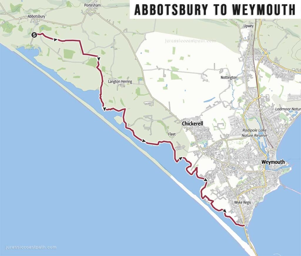
- Start: Abbotsbury Swannery Car Park, Grove Lane, Abbotsbury, Weymouth DT3 4JH Google map
- Finish: Weymouth
- Highlights: Chesil Beach, Fleet Lagoon, Weymouth seafront
Route Summary
This stage leaves Abbotsbury and follows a largely flat route along the inland side of Chesil Beach, with views across the Fleet Lagoon. The terrain is noticeably different from earlier sections, with long, steady stretches and minimal elevation change. The path is generally wide and well-defined, making for straightforward walking. The final approach into Weymouth follows coastal and urban paths, finishing along the seafront.
Elevation & Difficulty
With only around 120 metres of ascent, this is one of the easiest stages along the Jurassic Coast Path in terms of elevation. There are no significant climbs, and the terrain allows for a consistent pace throughout. The difficulty is primarily determined by the distance rather than the terrain, making this a relatively straightforward stage compared to earlier sections.
Highlights Along the Route
- Fleet Lagoon – Calm inland waters running parallel to the coast.
- Chesil Beach – Long shingle barrier stretching towards Portland.
- Open Coastal Views – Wide views across the lagoon and out to sea.
- Transition to Urban Coastline – Gradual approach into Weymouth.
- Weymouth Seafront – Sandy beach, harbour and full range of facilities.
Practical Information
- Parking (Abbotsbury): Car parks available in and around the village.
- Parking (Weymouth): Multiple car parks in the town centre and along the seafront.
- Public Transport: Good bus connections between Abbotsbury and Weymouth. Buses depart from outside the Ilchester Arms pub in West Street, which is a 15 min walk from the Swannery car park.
First Bus X52 & 53 Jurassic Coaster Weymouth – Abbotsbury (Ilchester Arms) – Burton Bradstock – West Bay – Bridport – Charmouth – Lyme Regis – Axminster - Toilets: Available in Abbotsbury and widely available in Weymouth.
- Food & Drink: Limited options in Abbotsbury; extensive choice in Weymouth.
- Water: Limited refill points along the route — carry sufficient water.
Navigation Notes
The route is straightforward and well signposted as part of the South West Coast Path. The path runs inland alongside Chesil Beach rather than directly on the shingle. Navigation is simple throughout, with no complex sections or diversions under normal conditions.
Safety Notes
This is a relatively safe and straightforward stage, with minimal exposure compared to earlier cliff sections. The main consideration is the exposed nature of the route, particularly in windy conditions. The long, open stretches offer limited shelter. There are no tide-dependent sections.
Suggested Walking Strategy
This stage works well as a steady full-day walk or a more relaxed day following earlier demanding sections. The flat terrain allows for a consistent pace, making it suitable for recovery. Walking towards Weymouth provides a logical finish with access to accommodation, food and transport.
Map & GPX
- View full route on Outdooractive
- Download GPX file
Previous Stage
Next Stage
Continue to: Weymouth → Osmington Mills