Stage Overview
- Distance: 12.1 miles / 19.5 km
- Time: 5h 15m
- Ascent: 315 m
- Difficulty: Demanding
- Terrain: Cliff paths, coastal tracks, some flatter sections inland and near Chesil Beach
- Navigation: Easy (generally well-defined paths)
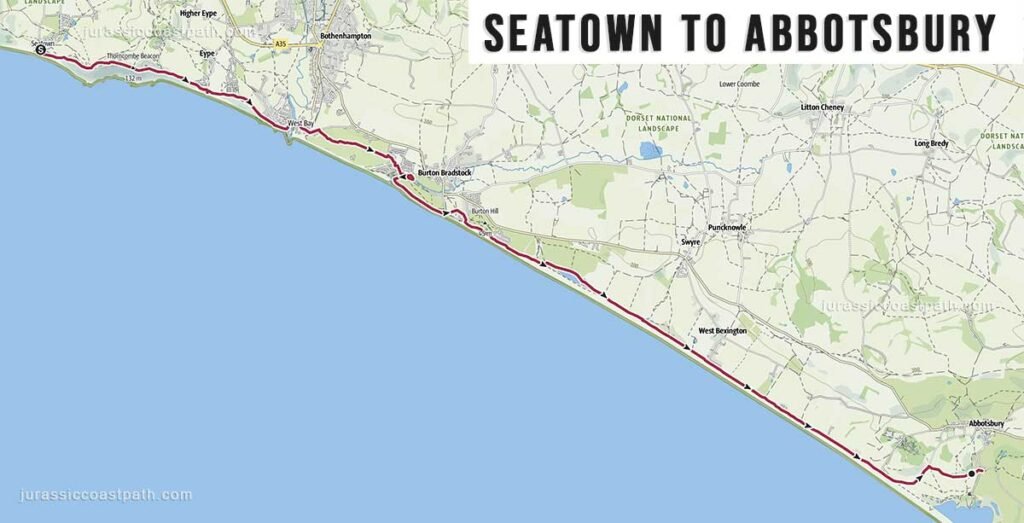
- Start: The Anchor Inn, Seatown, Bridport DT6 6JU Google map
- Finish: Abbotsbury Swannery Car Park, Grove Ln, Abbotsbury, Weymouth DT3 4JH Google map
- Highlights: Golden Cap views, Chesil Beach, quieter coastal stretches
Route Summary
This stage continues east from Seatown, initially climbing away from the coast before following a mix of cliff-top and inland paths. The route gradually becomes less rugged than earlier sections, with longer, more sustained stretches and fewer sharp ascents. As the walk progresses, the landscape opens out towards Chesil Beach, with the final section approaching Abbotsbury across flatter terrain. The stage finishes near the edge of the lagoon and village.
Elevation & Difficulty
Despite being one of the longer stages, the total ascent is relatively moderate at approximately 315 metres. The climbs are less frequent and less severe than earlier sections such as Lyme Regis → Seatown, resulting in a steadier and more consistent walking rhythm. The difficulty comes primarily from the distance rather than steep terrain, making this a long but less physically intense stage overall.
Highlights Along the Route
- Seatown Cliffs – Immediate views back towards Golden Cap and the surrounding coastline.
- Cliff-top Walking – Continued elevated sections with open coastal views.
- Transition to Chesil Beach – Noticeable change in landscape as the coastline becomes more open.
- Fleet Lagoon Views – Inland views across the lagoon as the route approaches Abbotsbury.
- Abbotsbury Village – Historic village with stone buildings and local attractions.
Practical Information
- Parking (Seatown): Limited parking near the beach.
- Parking (Abbotsbury): Car parks available in and around the village.
- Public Transport: No buses directly from Seatown. You will need to walk to nearby Chideok village on the main road. (20 min walk from Seatown Beach to Chideok Bridge bus stop)
First Bus X51 Jurassic Coaster Weymouth – Dorchester – Bridport – Chideok (Bridge) – Charmouth -Lyme Regis – Axminster
First Bus X53 Jurassic Coaster Weymouth – Abbotsbury (Ilchester Arms) – Burton Bradstock – West Bay – Bridport – Chideok (Bridge) – Charmouth – Lyme Regis – Axminster - Toilets: Limited facilities at Seatown; available in Abbotsbury.
- Food & Drink: Very limited options at Seatown; more available in Abbotsbury.
- Water: No reliable refill points along the route — carry sufficient water.
Navigation Notes
The route is generally straightforward and well signposted as part of the South West Coast Path. Some sections move slightly inland, particularly as the route approaches Chesil Beach, but the path remains clear. There are no significant navigation difficulties under normal conditions.
Safety Notes
The route includes some exposed cliff sections, though less severe than earlier stages. Paths may be uneven or muddy after rain. The length of the stage means that fatigue can become a factor, particularly in warm or windy conditions. There are no tide-dependent sections.
Suggested Walking Strategy
This is best approached as a full-day walk due to the distance involved. Although less steep than previous stages, the length requires steady pacing. An early start is advisable. This stage can feel more exposed due to the open landscape, so conditions should be considered. Walking from Seatown to Abbotsbury allows for a gradual transition into easier terrain compared to earlier sections.
Map & GPX
- View full route on Outdooractive
- Download GPX file
Previous Stage
Next Stage
Continue to: Abbotsbury → Weymouth