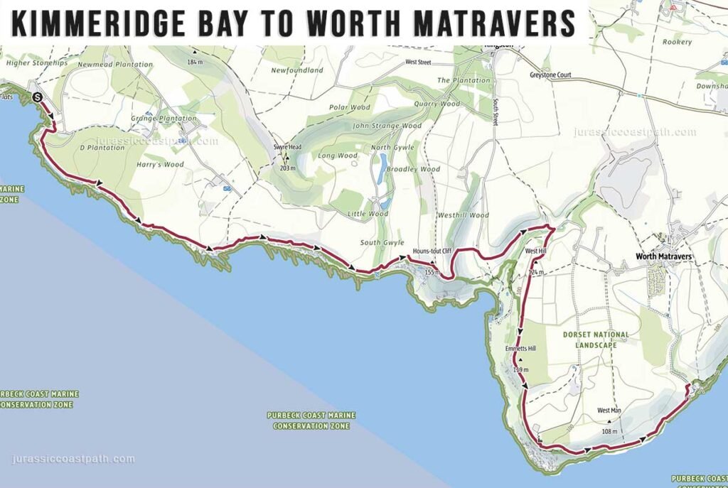
Stage Overview
- Distance: 7.3 miles / 11.7 km
- Time: 3h 40m
- Ascent: 350 m
- Difficulty: Moderate
- Terrain: Cliff paths, coastal tracks, some steep ascents and descents
- Navigation: Easy to Moderate (well signposted, some undulating terrain)
- Start: Kimmeridge
- Finish: Worth Matravers
- Highlights: Kimmeridge Bay, coastal cliffs, St Aldhelm’s Head
Route Summary
This stage leaves Kimmeridge Bay and climbs steadily onto the cliffs, continuing along a well-defined coastal path with a mix of moderate ascents and descents. The terrain remains varied but less intense than the previous stages, with a more consistent walking rhythm. The route passes St Aldhelm’s Head before turning inland slightly towards Worth Matravers, finishing in the village.
Elevation & Difficulty
With approximately 350 metres of ascent, this stage is moderate in difficulty. The climbs are present but less severe and less frequent than on the previous stages from Lulworth Cove. The terrain allows for a steadier pace, making this a more manageable section while still requiring a reasonable level of fitness.
Highlights Along the Route
- Kimmeridge Bay – Quiet coastal starting point with distinctive geology.
- Cliff-top Walking – Open coastal views along a less rugged section of coastline.
- St Aldhelm’s Head – Prominent headland with historic chapel and wide views.
- Coastal Landscape – Gradual transition to more open and less steep terrain.
- Worth Matravers Village – Traditional stone village marking the end of the stage.
Practical Information
- Parking (Kimmeridge): Limited parking near the bay.
- Parking (Worth Matravers): Limited parking within the village.
- Public Transport: Neither Kimmeridge nor Worth Matravers are served by public buses. The nearest bus stop to Kimmeridge is 5 miles away so, unless you have been lucky enough to find accommodation in Kimmeridge village you will have to take a taxi to/from a nearby town/village such as Corfe Castle, Wareham or Swanage.
Winspit Quarry (end of route section) is a 35 minute uphill walk to The Square and Compass pub in Worth Matravers village. The nearest bus stop to Worth Matravers village is at Worth Lane (Google map) on the Kingston to Swanage road which is another 25 min walk from the pub (2.5 miles, 60 min walk from Winspit Quarry) . - Morebus Purbeck Breezer 40: Swanage – Langton Matravers – Kingston – Corfe Castle – Wareham – Poole
- Toilets: Limited facilities at Kimmeridge; available in Worth Matravers.
- Food & Drink: Very limited options at Kimmeridge; available in Worth Matravers.
- Water: No reliable refill points along the route — carry sufficient water.
Navigation Notes
The route is clearly signposted as part of the South West Coast Path. Navigation is generally straightforward, with a continuous coastal path and clear waymarking. Care is needed on some undulating sections where paths may narrow, but there are no significant navigation difficulties under normal conditions.
Safety Notes
The route includes cliff-top paths with some exposed sections and uneven ground. Care is required near edges and on steeper sections, particularly in wet or windy conditions. While less demanding than previous stages, the terrain still requires attention.
Suggested Walking Strategy
This stage works well as a half-day walk or a more relaxed day following the demanding sections around Lulworth. The more moderate terrain allows for a steady pace. Walking from Kimmeridge to Worth Matravers provides a natural continuation along the coast and finishes in a quiet village setting.
Map & GPX
- View full route on Outdooractive
- Download GPX file
Previous Stage
Next Stage
Continue to: Worth Matravers → Swanage