Stage Overview
- Distance: 9.1 miles / 14.6 km
- Time: 4h 35m
- Ascent: 340 m
- Difficulty: Moderate
- Terrain: Cliff paths, coastal tracks, some steep sections, occasional inland diversions
- Navigation: Moderate (generally clear but some less defined sections)
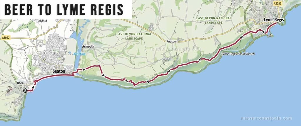
- Start: The Anchor Inn, Fore St, Beer, EX12 3ET Google map
- Finish: Cobb Gate (Millenium Clock), Marine Parade, Lyme Regis, DT7 3QD, Google map
- Highlights: Beer Head cliffs, Seaton, Lyme Regis harbour
Route Summary
This stage continues east from Beer, climbing out of the village onto the cliffs at Beer Head before following the coastline towards Seaton. After reaching Seaton, the route continues along a mix of coastal and slightly inland paths, with some sections moving away from the immediate cliff edge. The terrain is varied, combining open coastal walking with gentler stretches, before the final approach into Lyme Regis, descending towards the harbour and seafront.
Elevation & Difficulty
With approximately 340 metres of ascent, this stage is less demanding than the previous section from Sidmouth to Beer but still requires sustained effort. The climbs are more spaced out and less severe, creating a more balanced walking rhythm. While the distance is slightly longer, the reduced elevation gain makes this stage feel more manageable overall.
Highlights Along the Route
- Beer Head – Prominent headland with elevated views along the coast.
- Cliff-top Views – Open views across Lyme Bay for much of the route.
- Seaton – Coastal town with facilities and a useful midway point.
- Coastal Path Variations – Sections that move inland before returning to the coast.
- Lyme Regis Harbour (The Cobb) – Historic harbour marking the end of the stage.
Practical Information
- Parking (Beer): Limited parking near the village and beach.
- Parking (Lyme Regis): Several car parks, though can be busy in peak periods.
- Public Transport: Bus services connect Beer, Seaton and Lyme Regis, allowing flexible start and end points.
Axe Valley Mini Travel bus 899 Sidmouth – Branscome (some services) – Beer – Seaton – Axmouth
No direct buses to/from Lyme Regis, change at Seaton for AVMT bus 378 to/from Lyme Regis - Toilets: Available in Beer, Seaton and Lyme Regis.
- Food & Drink: Options available at all main settlements along the route.
- Water: No consistent refill points between towns — carry sufficient water.
Navigation Notes
The route is generally well signposted as part of the South West Coast Path. Some sections between Seaton and Lyme Regis move slightly inland, where the path may be less obvious — follow signage carefully. There are no significant diversions under normal conditions.
Safety Notes
The route includes cliff-top walking with some exposed sections and uneven ground. Care is required near edges and on steeper paths, particularly in wet conditions. Some inland sections may be muddy after rain. There are no tide-dependent sections on this stage.
Suggested Walking Strategy
This stage works well as a full-day walk but is less physically intense than the previous stage. Seaton provides a natural midpoint for a break or a shorter alternative walk. Walking from Beer to Lyme Regis is the natural direction, finishing in a larger town with more accommodation and facilities.
Map & GPX
- View full route on Outdooractive
- Download GPX file
Previous Stage
Next Stage
Continue to: Lyme Regis → Seatown